Globes, Atlases and Maps 471
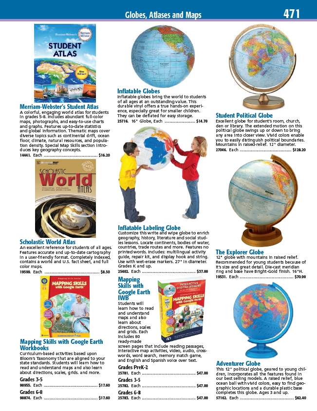
Student Political Globe
Excellent globe for student’s room, church,
den or library. The extended motion on this
political globe swings up or down to bring
any area into closer view. Vivid colors enable
you to easily distinguish political boundaries.
Mountains in raised-relief. 12" diameter.
27046. Each ............................................ $128.20
The Explorer Globe
12" globe with mountains in raised relief.
Recommended for young students because of
it’s size and great detail. Die-cast meridian
ring and base have Bright-Gold finish. 16"H.
19531. Each .............................................. $70.90
Adventurer Globe
This 12" political globe, geared to young children,
incorporates all the features found in
our best selling models. A raised relief, blue
ocean ball with vivid colors, easy to find geographic
locations and a durable plastic base
completes this globe. Ages 3 and up.
57162. Each .............................................. $62.40
Merriam-Webster’s Student Atlas
A colorful, engaging world atlas for students
in grades 5-8. Includes abundant full-color
maps, photographs, and easy-to-use charts
and graphs. Features up-to-date statistics
and global information. Thematic maps cover
diverse topics such as continental drift, ocean
floor, climate, natural resources, and population
density. Special Map Skills section introduces
key geography concepts.
14441. Each .............................................. $16.20
Inflatable Globes
Inflatable globes bring the world to students
of all ages at an outstanding value. This
durable vinyl offers a true hands-on experience,
especially great for smaller children.
They can be deflated for easy storage.
25716. 16" Globe, Each .......................... $14.70
Inflatable Labeling Globe
Customize this write and wipe globe to enrich
geography, history, literature and social studies
lessons. Locate continents, bodies of water,
countries, trade routes and more. Features no
printed words. Includes: multilingual activity
guide, repair kit, and display hook and string.
Use with wet-erase markers. 27" in diameter.
Grades K and up.
25402. Each .............................................. $37.00
Mapping
Skills with
Google Earth
IWB
Students will
learn how to read
and understand
maps and also
learn about
directions, scales
and grids. Each
includes 80
ready-made
screen pages that include reading passages,
interactive map activities, video, audio, crosswords,
word search, memory match game,
and English and Spanish voice over text.
Grades PreK-2
25781. Each .............................................. $47.00
Grades 3-5
25782. Each .............................................. $47.00
Grades 6-8
25783. Each .............................................. $47.00
Scholastic World Atlas
An excellent reference for students of all ages.
Features accurate and up-to-date cartography
in a user-friendly format. Completely indexed,
contains a world and U.S. fact sheet, and full
color maps.
19599. Each ............................................... $8.50
Mapping Skills with Google Earth
Workbooks
Curriculum-based activities based upon
Bloom’s Taxonomy that are aligned to your
state standards. Students will learn how to
read and understand maps and also learn
about directions, scales, grids. and more.
Grades 3-5
98955. Each .............................................. $17.60
Grades 6-8
98874. Each .............................................. $17.60
/ViewItem?mdsecode=27046
/ViewItem?mdsecode=57162
/ViewItem?mdsecode=19531
/ViewItem?mdsecode=14441
/ViewItem?mdsecode=25781
/ViewItem?mdsecode=25782
/ViewItem?mdsecode=25783
/ViewItem?mdsecode=25716
/ViewItem?mdsecode=25402
/ViewItem?mdsecode=19599
/ViewItem?mdsecode=98955
/ViewItem?mdsecode=98874